CAD & GIS News for Govies 2/14
CAD News for Govies is a weekly feature on Acronym that scans thousands of industry articles to present you with a regular source of CAD and GIS news, events, and ideas that impact the public sector. Here’s the latest round-up:
Mapping the 2014 Sochi Winter Olympics in Google Earth
CAD & GIS News for Govies 1/7
CAD News for Govies is a weekly feature on Acronym that scans thousands of industry articles to present you with a regular source of CAD and GIS news, information and ideas that impact the public sector. Here’s the latest round-up:
Pay-As-You-Go Design Software – Why Renting Makes Sense from an IT Perspective
The New Norm: Work the Way You Live
CAD & GIS News for Govies 9/18
CAD News for Govies is a weekly feature on Acronym that scans thousands of industry articles to present you with a regular source of CAD and GIS news, information and ideas that impact the public sector.
Here’s the latest round-up:
Calling All Architects and Engineers: 3 Steps to Tap into Visualization with 3ds Max
Government Officials Realize the Power of Rendered Animations and Time Lapse 3D Visualizations
Time lapse video has been used for decades to show the progress of some of the world’s most awe inspiring innovations – from Olympic stadiums to aircraft, ship building and more. Most recently the progress of New York City’s One World Trade Center has been captured via a construction site “job-cam”. The video spans the period from October, 2004 to September, 2013 and was hand-edited from hundreds of thousands of high-definition images captured of work at the site. Prominently featured is the rise of One World Trade Center.
Potential Syrian Missile Targets Pinpointed in Google Earth
As the U.S. government continues the debate about potential strikes against the Assad regime in Syria, GIS professionals are busy mapping out potential missile targets in Google Maps and Google Earth.
ForeignPolicy.com, for example, has mapped 36 locations in Syria that represent the most likely targets for U.S. missiles.
While the goal of the attacks is still unclear, it seems plausible that the strikes will target chemical plants, arms depots, airfields and other military assets.
New eBook - Ubiquitous Tools from Google can Help Emergency Management Personnel Before, During and After a Crisis
[caption id="attachment_4375" align="alignright" width="300"]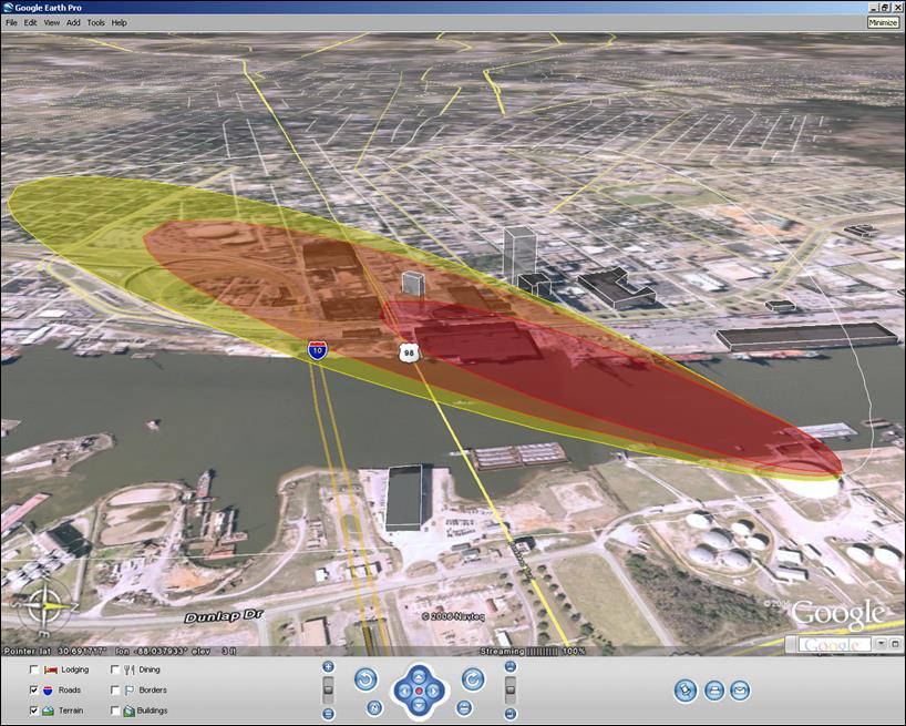 A red and yellow cloud plume overlaid on a Google Earth aerial map helps first responders assess and rehearse for disaster scenarios.[/caption]