Some of the largest states and construction firms in the United States have begun to adopt 3D modeling software such as AutoCAD
® Civil 3D
® software for engineering design. Many state departments of transportation are already looking at the benefits of 3D modeling over traditional 2D programs. This trend has also begun to percolate from the national and state level down to cities and counties. DOTs and engineering consultants who have made the move to 3D have begun to explore some of the opportunities for greater efficiency, improved designs and better cost management that the use of 3D models provide. Here are some of the ways modeling software has transformed large transportation project design and development.
Project Visualization
With large transportation projects, public meetings and consultations often spur design changes. Most people don’t know how to read traditional 2D drawings, so a 3D drive through or fly-by of the project immediately communicates the engineer’s design intent. By showing people a photo-realistic rendering of what the project might look like from different perspectives, consultations with the public, with contractors and other government agencies can be more productive and efficient. In Autodesk Civil 3D, there is literally a drive-through function that allows engineers to easily develop movies of how drivers might experience a proposed design. This is revolutionary in transportation project communication. Before 3D modeling, it was prohibitively expensive to develop drive-throughs and designers rarely created them – but with the advent of 3D many are finding that these illustrations are invaluable when presenting plans to the many constituents involved in approving and building a transportation project. For example, engineers are beginning to use the model to explore safety aspects of the project in a visually accurate manner. They can look at passing and stopping site distances, as well as spot blind corners or intersections and then make design tweaks to improve road safety.

3D Visualization of San Francisco – Oakland Bay Bridge, by Randy Burton of Parson Brinckerhoff
Accelerating Approvals
There are a myriad of approvals and permits required when building large roadway infrastructure projects. These include federal, state, and county level environmental agencies, water management regulatory bodies, as well as the actual counties and cities impacted by the projects. Each of these regulatory bodies requires specific information and associated drawings for permit and approval reviews. Prior to information modeling, these drawings would be produced on a one-off basis, and considering that designs often change in large civil projects, would require frequent updating. Now, using a 3D model the project team can simply call up the view required in the model and obtain the necessary information far more quickly and easily. Approvals and permitting information and drawings are simply subsets of the information already included in the model. For example, for water management approvals, engineers need to detail the pre-construction flow conditions and the post-construction flow conditions to design drainage management systems. This is a very dynamic area of investigation and can be time intensive – especially when the design changes. However, because the information in the model provides accurate guidelines, engineers can perform water flow calculations more quickly than ever before. And, when the model changes, so too will the corresponding drainage analysis.

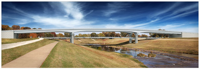
Fort Worth - Clearfork Main Street Bridge, by Claudio Branch, Freese and Nichols
Managing Costs
Billions of dollars spent on public infrastructure projects can be better managed if the project constituents use design engineering modeling throughout the project’s lifecycle. At the early design stage, engineers can present more than one design option in order to receive agreement from the various stakeholders. As the design work proceeds and changes are made in response to environmental or social requirements, engineers can now use the model to readily calculate the cost of alterations without significant manual work. Prior to and during construction, the project team can view the construction sequence virtually in order to create a schedule that optimizes both human and machine assets, as well as reduce conflicts and potential safety issues. After construction, the model can populate asset management systems. This allows road maintenance crews and owners to schedule and maintain the new asset to extend its life and ensure safety.
Virtual Construction
Whether adding another lane, creating a new intersection or otherwise altering an existing roadway, keeping the project on schedule and on budget is of paramount importance. Using a model and placing it into a tool such as Autodesk
® Navisworks
®, allows the construction team to schedule and build the entire project virtually to help identify conflicts ahead of time and minimize the number of change orders. This type of analysis also aids in public safety as traffic management plans can be created and communicated well ahead of time.
These are just some of the many changes to the way transportation projects are being conceived of, designed and constructed in the post-modeling world. As more engineers and transportation departments adopt 3D modeling, more innovation will occur. We’ll continue to report on this topic as we all move forward.

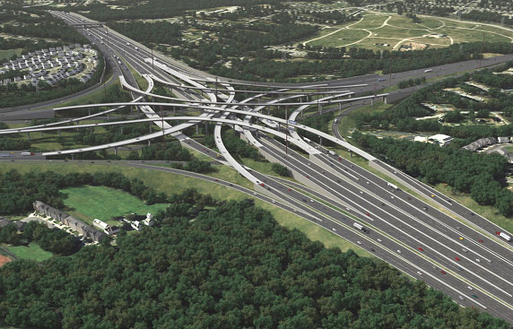
I-95 / I-695 Interchange, by Glen Lloyd of Parsons Brinckerhoff
By Joe Hedrick, LS, EIT
Infrastructure Solutions Team Manager, IMAGINiT Technologies
About Joe Hedrick, LS, EIT
As a manager for IMAGINiT’s Infrastructure Solutions team, Joe oversees the civil and survey application engineers in the eastern half of the United States and provides Autodesk civil engineering and survey implementation consulting services. www.imaginit.com
All images courtesy of IMAGINiT Technologies.
 Some of the largest states and construction firms in the United States have begun to adopt 3D modeling software such as AutoCAD® Civil 3D® software for engineering design. Many state departments of transportation are already looking at the benefits of 3D modeling over traditional 2D programs. This trend has also begun to percolate from the national and state level down to cities and counties. DOTs and engineering consultants who have made the move to 3D have begun to explore some of the opportunities for greater efficiency, improved designs and better cost management that the use of 3D models provide. Here are some of the ways modeling software has transformed large transportation project design and development.
Project Visualization
With large transportation projects, public meetings and consultations often spur design changes. Most people don’t know how to read traditional 2D drawings, so a 3D drive through or fly-by of the project immediately communicates the engineer’s design intent. By showing people a photo-realistic rendering of what the project might look like from different perspectives, consultations with the public, with contractors and other government agencies can be more productive and efficient. In Autodesk Civil 3D, there is literally a drive-through function that allows engineers to easily develop movies of how drivers might experience a proposed design. This is revolutionary in transportation project communication. Before 3D modeling, it was prohibitively expensive to develop drive-throughs and designers rarely created them – but with the advent of 3D many are finding that these illustrations are invaluable when presenting plans to the many constituents involved in approving and building a transportation project. For example, engineers are beginning to use the model to explore safety aspects of the project in a visually accurate manner. They can look at passing and stopping site distances, as well as spot blind corners or intersections and then make design tweaks to improve road safety.
 3D Visualization of San Francisco – Oakland Bay Bridge, by Randy Burton of Parson Brinckerhoff
Accelerating Approvals
There are a myriad of approvals and permits required when building large roadway infrastructure projects. These include federal, state, and county level environmental agencies, water management regulatory bodies, as well as the actual counties and cities impacted by the projects. Each of these regulatory bodies requires specific information and associated drawings for permit and approval reviews. Prior to information modeling, these drawings would be produced on a one-off basis, and considering that designs often change in large civil projects, would require frequent updating. Now, using a 3D model the project team can simply call up the view required in the model and obtain the necessary information far more quickly and easily. Approvals and permitting information and drawings are simply subsets of the information already included in the model. For example, for water management approvals, engineers need to detail the pre-construction flow conditions and the post-construction flow conditions to design drainage management systems. This is a very dynamic area of investigation and can be time intensive – especially when the design changes. However, because the information in the model provides accurate guidelines, engineers can perform water flow calculations more quickly than ever before. And, when the model changes, so too will the corresponding drainage analysis.
 Fort Worth - Clearfork Main Street Bridge, by Claudio Branch, Freese and Nichols
Managing Costs
Billions of dollars spent on public infrastructure projects can be better managed if the project constituents use design engineering modeling throughout the project’s lifecycle. At the early design stage, engineers can present more than one design option in order to receive agreement from the various stakeholders. As the design work proceeds and changes are made in response to environmental or social requirements, engineers can now use the model to readily calculate the cost of alterations without significant manual work. Prior to and during construction, the project team can view the construction sequence virtually in order to create a schedule that optimizes both human and machine assets, as well as reduce conflicts and potential safety issues. After construction, the model can populate asset management systems. This allows road maintenance crews and owners to schedule and maintain the new asset to extend its life and ensure safety.
Virtual Construction
Whether adding another lane, creating a new intersection or otherwise altering an existing roadway, keeping the project on schedule and on budget is of paramount importance. Using a model and placing it into a tool such as Autodesk® Navisworks®, allows the construction team to schedule and build the entire project virtually to help identify conflicts ahead of time and minimize the number of change orders. This type of analysis also aids in public safety as traffic management plans can be created and communicated well ahead of time.
These are just some of the many changes to the way transportation projects are being conceived of, designed and constructed in the post-modeling world. As more engineers and transportation departments adopt 3D modeling, more innovation will occur. We’ll continue to report on this topic as we all move forward.
 I-95 / I-695 Interchange, by Glen Lloyd of Parsons Brinckerhoff
By Joe Hedrick, LS, EIT
Infrastructure Solutions Team Manager, IMAGINiT Technologies
About Joe Hedrick, LS, EIT
As a manager for IMAGINiT’s Infrastructure Solutions team, Joe oversees the civil and survey application engineers in the eastern half of the United States and provides Autodesk civil engineering and survey implementation consulting services. www.imaginit.com
All images courtesy of IMAGINiT Technologies.


