CAD & GIS News for Govies 2/20
CAD News for Govies is a weekly feature on Acronym that scans thousands of industry articles to present you with a regular source of CAD and GIS news, events, and ideas that impact the public sector. Here’s the latest round-up:
County Officials Share GIS Data to Bring Efficiencies to Everyday Citizen Life
CAD & GIS News for Govies 1/16
CAD News for Govies is a weekly feature on Acronym that scans thousands of industry articles to present you with a regular source of CAD and GIS news, information and ideas that impact the public sector. Here’s the latest round-up:
8 Public Works Problems Solved
CAD & GIS News for Govies 11/20
CAD News for Govies is a weekly feature on Acronym that scans thousands of industry articles to present you with a regular source of CAD and GIS news, information and ideas that impact the public sector. Here’s the latest round-up:
Is it Possible To Design Buildings That Can Withstand 250 MPH Typhoon Winds?
CAD & GIS News for Govies 10/16
CAD News for Govies is a weekly feature on Acronym that scans thousands of industry articles to present you with a regular source of CAD and GIS news, information and ideas that impact the public sector.

Here’s the latest round-up:
New Construction Management Software Designed Around iPhone Usability
NGA Explores Sharing Cloud-Based GIS Information to Aid in Disaster Recovery
One of the biggest challenges that first responders face when dealing with the aftermath of a disaster is sharing GIS data across disparate IT systems. It’s a problem we discuss extensively in this free ebook – Google Emergency Management Tools for Govies.
Potential Syrian Missile Targets Pinpointed in Google Earth
As the U.S. government continues the debate about potential strikes against the Assad regime in Syria, GIS professionals are busy mapping out potential missile targets in Google Maps and Google Earth.
ForeignPolicy.com, for example, has mapped 36 locations in Syria that represent the most likely targets for U.S. missiles.
While the goal of the attacks is still unclear, it seems plausible that the strikes will target chemical plants, arms depots, airfields and other military assets.
New eBook - Ubiquitous Tools from Google can Help Emergency Management Personnel Before, During and After a Crisis
[caption id="attachment_4375" align="alignright" width="300"]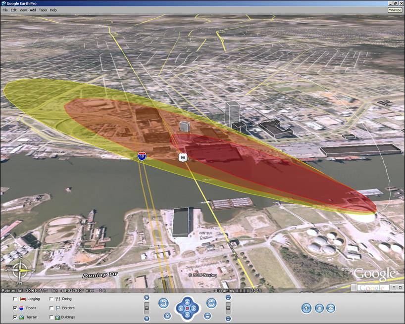 A red and yellow cloud plume overlaid on a Google Earth aerial map helps first responders assess and rehearse for disaster scenarios.[/caption]
CAD & GIS News for Govies 8/14
CAD News for Govies is a weekly feature on Acronym that scans thousands of industry articles to present you with a regular source of CAD and GIS news, information and ideas that impact the public sector.
Here’s the latest round-up:
Training Budget Slashed? Learn How Virtual Events can Help
CAD & GIS News for Govies 7/31
CAD News for Govies is a weekly feature on Acronym that scans thousands of industry articles to present you with a regular source of CAD and GIS news, information and ideas that impact the public sector.
Here’s the latest round-up:
How to Create a Killer CAD Team: Get Them Certified