 Some of us - including myself – may read a Dummies book and experience “sensory overload”. For those of you who are learning about LiDAR and how it works, here is some basic knowledge (drawn from this free “LiDAR for Dummies” ebook ) that can help you understand this system better and how it can help optimize your surveying activities.
LiDAR 101
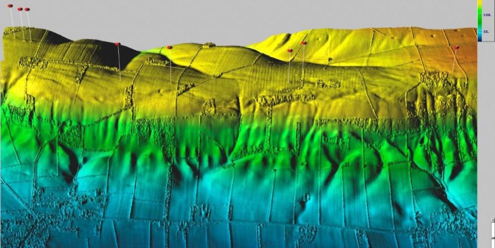
- What is LiDAR? – LiDAR is an optical remote sensing technology that can measure the distance to, or other properties of a target by illuminating the target with light. In short, almost like radar. It uses light waves, opposed to radio waves, and collects data that provides 3D information for a project area.
- How is it used? – LiDAR is no different from conventional surveying. Setting requirements early will help determine if you should collect your data through aerial, terrestrial, or mobile methods.
- The Power of LiDAR – Night vision is a feature that this system posses. Unfortunately, it can’t see through clouds, fog, smoke, or rain. With that said, it would be best to take seasons into consideration before you start collecting data.
- Where is the Best Place to Use this System? – When using LiDAR, you’re going to get a great data set. However, the higher the number of points within the data set, the better the definition of the data set is going to be.
- Collecting Data – The collection of data is typically done with some sort of aircraft, including helicopters and planes for large areas. For smaller areas, make sure you have leaf-off conditions.
- Remember to Calibrate – All sensors should be calibrated routinely. Terrestrial scanners have self calibrations before every collection and most specifications require an accuracy of between 5 and 10 centimeters vertically.
Usual Methods for Capturing Data
You can use different capture techniques for different accuracy ranges, uses, and costs. Check out the four primary techniques that you may consider using.
- Flying High – The higher you fly the lower the accuracy of sensors. This is practiced when mapping a state or county. To be accurate for a high-altitude project, be sure that you are in the neighborhood of 9.25 to 18.5 centimeters vertically and 20 centimeters to 1 meter horizontally.
- Flying Low – This is your best bet if using transportation corridors. Sensors can be flown in altitudes between 50 and 800 meters.
- Going Mobile – Used when large areas need to be mapped with high accuracy, mobile mapping LiDAR systems include two to four cameras that capture up to three frames per second.
- Terrestrial Use – Highly accurate and comparatively simple and inexpensive, Terrestrial scanners are stationary and are meant to use for a very specific area of interest.
Processing Data
Now it’s time for the fun part…processing data. These tools are typical for all LiDAR providers but the techniques may vary from one provider to another.
- Pre-processing – Using the “recipe” you’ll need to pull data into its raw format by focusing on first the laser data and positional raw data, then the ground base station data, and finally the raw GPS and IMU data.
- Post-processing – First adjust the raw LAS data to match the ground control, and then you mix your raw point data with any imagery you may have collected with LiDAR. Next , change the point classification from undefined to what the point actually represent, and finally, create linear feature from the data.
To learn more about LiDAR, how it works, and working with data, download this free “LiDAR for Dummies” ebook at www.dlt.com/LiDARforDummies.
Related Blog Posts


