CAD News for Govies is a new feature on Acronym that scans thousands of industry articles to present you with a regular source of CAD and GIS news, information and ideas that impact the public sector.
Here’s the latest round-up:
Tune in to Lynn Allen’s First AutoCAD Design Suite 2014 Webinar
 Last week, Autodesk Technical Evangelist, Lynn Allen hosted her first AutoCAD Design Suite 2014 webinar in partnership with Novedge. The one hour event is now available to view on-demand and includes an overview of Autodesk Recap, Geographic Location and the new interactive Design Feed, not to mention all those great everyday command improvements. You’ll also learn all about the other products in the AutoCAD Design Suite including its newest member, Raster Design.View the archived event here.
Autodesk 2014 Suites – So what’s Changed for Subscription Customers?
As you’d expect each Suite has new features in the latest 2014 release from Autodesk, but what about those of you who are on Subscription with a product suite? Well, you have access to a whole new toolset. Read more at the Autodesk Manufacturing and Digital Prototyping blog.
The Transportation Reauthorization Bill and Civil 3D
On July 6, 2012, President Obama signed into law a new two year transportation reauthorization bill, the Moving Ahead for Progress in the 21st Century Act. The Act funds surface transportation programs at over $105 billion for FY 2013 and 2014 and transforms the framework for investments to guide the growth and development of the country’s vital transportation infrastructure. Now what does all this have to do with Civil 3D? The Act promotes “innovative project delivery…(and) the use of innovative technologies and practices that increase the efficiency of construction, accelerate construction, improve the safety, improve the quality, reduce congestion from construction, and extend the service life of highways and bridges”. Civil 3D and the BIM process sounds like the perfect fit – read more at the IMAGINiT Technologies blog.
Oklahoma Tornado Highlights Need to Get "Tech Ready"
In the light of last week’s horrific events in Oklahoma, the use of everyday technology is playing a critical role in how citizens prepare for, adapt and recover from disasters. Cell phones and social media spring to mind, but also equally important is the use of cloud technology, power back-up systems, and power conservation efforts. FEMA’s Get Tech Ready page instructs citizens on how to use consumer technology and social media to prepare for and respond to an emergency. From backing-up important data such as health insurance information in the cloud or on a removable drive to ensuring cell phones are optimized to leverage emergency text and alerts from FEMA and other authorities. Read more on Government Technology.
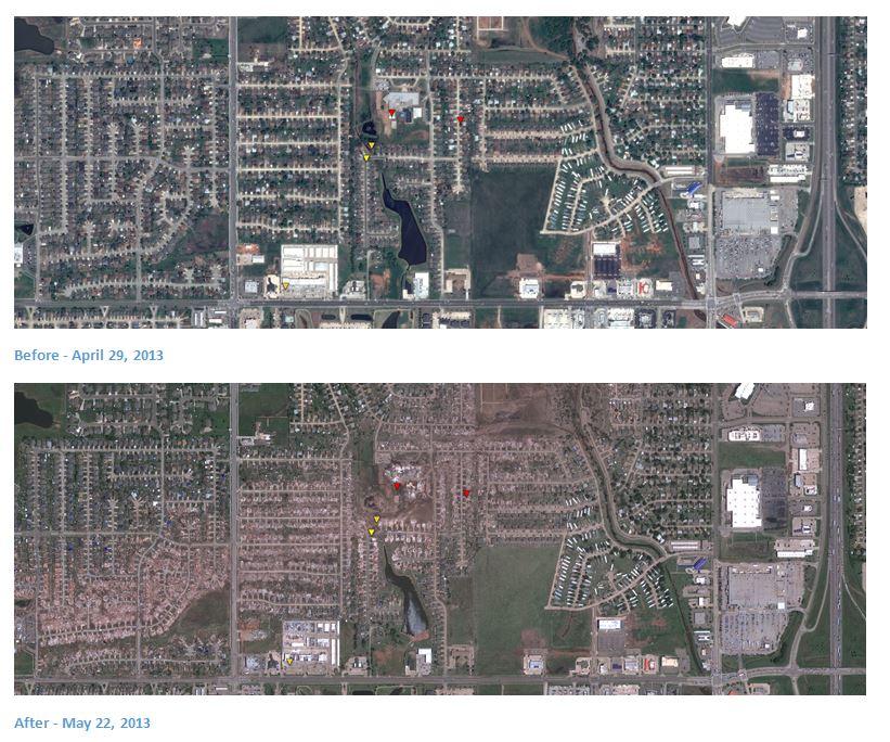
Post-Tornado Imagery – Google Crisis Map
Google has posted pre- and post-tornado imagery showing the devastating damage caused by the May 13 tornado. The interactive Google Crisis Map also includes aerial imagery taken at the end of April so you can compare the area before and after the deadly strike. The map also includes damage severity indicators, shelter locations, public alerts, and more.

New on Acronym
Don’t forget to check out the latest blogs on Acronym:
About Caron
Caron Beesley is the Editor in Chief of [acronym] Online. Caron has led the editorial team since [acronym] was launched in 2006 and has written several guides designed to help the public sector leverage information technology and digital design solutions to improve government operations and the delivery of public services. Caron is also the point of contact for contributed articles and guest bloggers. Contact Caron at editor@acronymonline.org or via Twitter @AcronymOnline.
Related Blog Posts


