
Flooding is one of the deadliest natural disasters. Few places can escape the wrath of excessive rain, ruptured dams or levees, rapid ice melt, or storm surges. Even states that we’d consider “dry” are vulnerable to the effects of flooding.
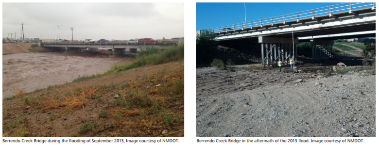
Such was the case in New Mexico in 2013 when multiple days of record rainfall led to widespread flooding. Over four inches of rain led the usually dry Berrendo Creek to flood, sending water and debris nearly over the top of a steel bridge on U.S. 285. The bridge, built in 1963, and already in poor condition failed to meet today’s design standards.
New Mexico Department of Transportation (NMDOT) sought to replace the bridge’s deck and steel girders, rehabilitate the existing substructure and ensure that the new design could withstand being overtopped by water.
Typically, on a project such as this, NMDOT was responsible for the road design, while an outside consultant would take responsibility for the bridge design (using AutoCAD Civil 3D). Such disparity would normally present a big problem since the design workflow between the consultants and NMDOT was cumbersome and involved a lot of manual effort and adjustment to combine design information for the bridge, road, and surrounding topography.
Moving to BIM
However, prior to commencing the project, NMDOT made the decision to move to Autodesk BIM solutions which ensured that the bridge designers and NMDOT road and survey teams were all working off Civil 3D software. Doing so made it easier to share road and bridge models across the teams. Furthermore, all project teams could use the survey data of existing conditions without needing to convert or translate it. Plus, with any changes made to the bridge design the road elevations updated automatically.
“With Civil 3D, we have an automatically adjusting 3D project model, where our survey and road alignments, profiles, and grading mesh seamlessly with the bridge design,” Jessica Hunter, Project Development Engineer at NMDOT explains in this case study.
With a reduction in change orders, project costs were significantly reduced.
Another Autodesk BIM solution, InfraWorks 360, was also piloted by NMDOT to develop project animations on the visualization of a complex roadway rehabilitation project.
“We used InfraWorks software to create a 3D visualization model of the project, including the new interchange as well as imported aerial photography, digital terrain models, and survey data of the surrounding terrain,” explained Scott May, IT Application Developer with NMDOT.
The visualization – set in the context of the existing surroundings – gave stakeholders a virtual fly through of the redesign and a better understanding of the new construction.
Learn more about this and other projects on which NMDOT has leveraged Civil 3D and InfraWorks 360.
Related Blog Posts


