Google Maps Engine Streamlines Emergency Management

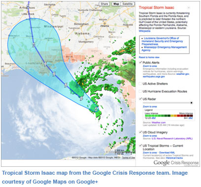
When you need directions to a location, where do you go to find them? If you’re like most people, you go to Google Maps. It’s the most popular mapping application in the world. Its companion application, Google Earth, has been downloaded more than 950 million times. But these familiar tools aren’t just for personal use. They’re also being used in crisis response situations, helping city and county governments to make critical information accessible to their response teams and to the public. Google Maps Engine, formerly known as Google Earth Builder, is a combination of Google Maps, Google Earth and other tools organized to help government organizations streamline emergency management processes.
Google Maps Engine offers a number of advantages to government agencies, as compared with standard geospatial software, says Mike Evanoff, Google geospatial engineer. For instance:
- Avoid downtime. Because the application runs on Google’s infrastructure, uptime is guaranteed. There’s no risk of a crash when your website gets thousands of hits in the wake of a crisis.
- Easy to use. Most team members are familiar with Google and its tools. They can use the same familiar system to upload data, such as local maps or photographs of damage, from their hard drives to the Google server. There’s no need to install any software or programs on your computers.
- Maintain privacy and ownership. Anything you upload to Google Maps Engine is protected by your account password and you can choose who to share it with, whether that’s other emergency response team members or the public. Google has no rights to it; the data still belongs to you.
- Compare new data with existing data. When a hurricane or tornado affects your area, you can compare new photographs of damaged areas with existing images from Google Earth to determine or communicate levels of damage.
- Go mobile. Because Google Maps Engine is a web-based platform, it can be used on the go with a smart phone. This means emergency responders who are working in the field can access real-time information about locations affected by crises and react accordingly.
Google Maps Engine includes a variety of tools to make emergency response easier and faster. Some of the product’s components include the following.
Google Latitude
This tool is a location-aware mobile app, which shows you where other users are located at any given moment. By activating this tool on the mobile phones of every team member, it allows emergency response teams to coordinate their efforts and keep tabs on each other.
Google Coordinate
A new addition to the Google Maps Engine, Google Maps Coordinate is a workforce management tool that improves the efficiency of your mobile teams. Headquarters staff can see team members on a Google Map, making it easy to assign jobs to the nearest available team member. The tool also includes an Android app for mobile workers so they can see where different team members are and where the jobs are in real time. A database component remembers where everyone was during the day, which jobs were completed, and how long each job took, providing valuable analysis. By getting real-time visibility into where teams are and what jobs they are doing, work can be scheduled in a smarter, more efficient way.
Google Earth Portable
Sometimes, a crisis may take out Internet access for long periods of time. In those cases, Google Earth Portable comes in handy. “If you have no Internet access, you can take a chunk of your globe with you,” Evanoff says. “For instance, you can download a 30-gig piece of data, put it on your hard drive, and take it with you.”
 Learn more about Google Maps Engine by viewing a webinar on the topic, presented by Evanoff and sponsored by DLT Solutions. Click here to view it on demand.
By Nancy Mann-Jackson
Nancy Mann Jackson is a freelance journalist who writes regularly about local government and sustainability issues. Learn more about her at www.nancyjackson.com.


